

Air Quality Experiment: Indoor V. Outdoor
September 4, 2020
Create a Science Poster
April 29, 2021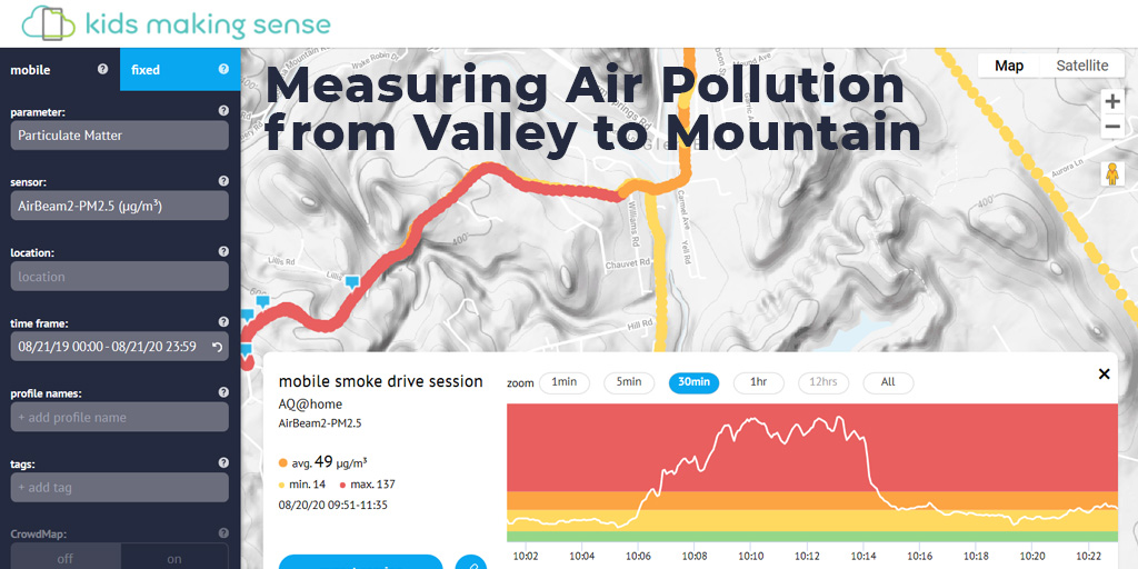
Free Resources > Valley to Mountain
Air Quality Experiment: Valley to Mountain
You can design a simple experiment to study air quality at different altitudes by using your Kids Making Sense® particulate matter (PM) sensor. This could be done at any point in time, though the example below was done during a wildfire event, when the effects of altitude were more pronounced.
- Begin by measuring PM levels around the neighborhood, then carefully secure the particle sensor so you can measure the outside air while carefully driving up a hill or mountain. You could do this by securely holding the air sensor so the inlet is pointing out of the window
- As you slowly drive around, be sure to make notes of changes you observe visually. Does the air look more smokey or less smokey? If you do this on a clear day, are you above the cloud level (can you see clouds below you?)
- What do you find during your experiment? Is the air quality better or worse at the top of the mountain?
- Can you explain your results?
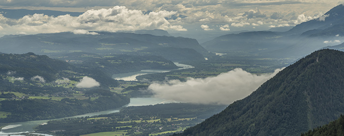
Caption: An example of what it might look like if you do this experiment on a clear day and are above the clouds. Notice that some clouds appear below you in this example.
We tried it when smoke from local wildfires was impacting the area and saw very interesting results! We expected the air to be cleaner at the top of the mountain, but found the smoke was worse at the top! Why? The smoke plumes were lofted high in the atmosphere. This is why there were low pollution readings in the valley, even though the sky looked thick with smoke.

To check out our session on the mapping site, click here: https://bit.ly/2QaRbnJ
TIP: when you look at your session on the kidsmakingsense.org/maps website, turn on the “terrain satellite” view to better see the topography of the area (as shown above).
As with any scientific experiment, the value is in understanding why we got these results and what they can tell us. In certain locations, seasons, or under certain atmospheric conditions, you may see higher levels at the base of the mountain. Perhaps the pollution gets trapped in the valley during the summer or winter. At other times, you might see higher values at the top, just like we found. Sometimes there might not be much of a change at all!
This highlights the fact that similar experiments can often result in different outcomes - the value is in understanding why! What will your students discover when they conduct their own experiments?